What are Census Summary Levels (SUMLEV)?
Planning Data
Kristen Carney
If you're using Mara's excellent instructions for working with Census 2010 data, you'll need to know about Summary Levels or SUMLEVs in step 6.
What are Census Summary Levels (SUMLEV)?
Simple Answer: SUMLEV is a Census Bureau code to indicate geography type. For example, in the raw Census 2010 data, all states have a SUMLEV code of "040."
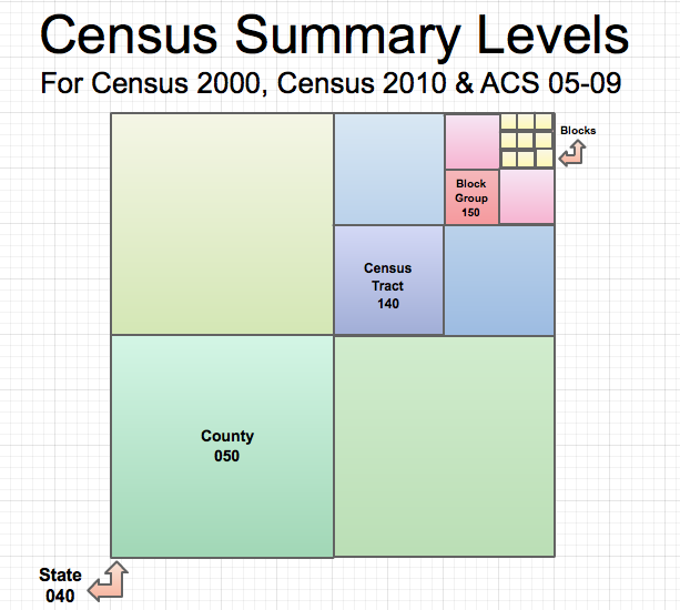
A Touch of Complexity: SUMLEVs also designate hierarchical relationships for the geographies. For example, a SUMLEV of "050" indicates a County WITHIN a State. A SUMLEV of "140" indicates a Census Tract within a County within a State.
Below is a chart showing SUMLEVs for common geographies.
| Geographies | SUMELV | Hierarchy |
|---|---|---|
| Census 2000 & 2010 | ||
| State | 040 | State |
| County | 050 | State-County |
| County Subdivison | 060 | State-County-County Subdivision |
| Tract | 140 | State-County-Tract |
| Block Group | 150 | State-County-Tract-Block Group |
| Place(aka City) | 160 | State-Place |
Odd Man Out: Census Blocks
Census Blocks have different Summary levels for Census 2000 and Census 2010.
- For Census 2000, the SUMLEV for Census Blocks is 101. The geographical hierarchy is State-County-County Subdivision-Place/Remainder-Tract-Block Group-Block.
- For the Census 2010, the SUMLEV for Census Blocks are either 750 with a hierarchy of State-County-VotingDistrict/Remainder-County Subdivision-Place/Remainder-Tract-Block Group-Block OR 755 with a hierarchy of State-County-VotingDistrict/Remainder-County Subdivision-Subminor Civil Division-Tract-Block Group-Block.
Below are the original sources for Summary Level data from the Census Bureau. Use these to look up a geography types and SUMLEVs that aren't listed above.
- Census 2000, Page 4 - 1, http://www.census.gov/prod/cen2000/doc/sf1.pdf
- Census 2010, Page 4 - 1, http://www.census.gov/prod/cen2010/doc/pl94-171.pdf
- American Community Survey ftp://ftp2.census.gov/acs2009_5yr/prod/Geography_Summary_Levels_and_Components.pdf
1 Comment
-
With the release of 2010 SF1 data it looks like the Census Block SUMLEV code is 101 rather than the 750/755 noted in the PL94-171.
http://www.census.gov/prod/cen2010/doc/sf1.pdf