If you’re using Mara’s excellent instructions for working with Census 2010 data, you’ll need to know about Summary Levels or SUMLEVs in step 6.
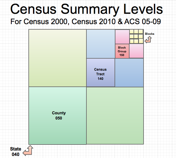
What are Census Summary Levels (SUMLEV)?
Simple Answer: SUMLEV is a Census Bureau code to indicate geography type. For example, in the raw Census 2010 data, all states have a SUMLEV code of “040.”
A Touch of Complexity: SUMLEVs also designate hierarchical relationships for the geographies. For example, a SUMLEV of “050” indicates a County WITHIN a State. A SUMLEV of “140” indicates a Census Tract within a County within a State.
Below is a chart showing SUMLEVs for common geographies.
| Geographies | SUMELV | Hierarchy |
|---|---|---|
| Census 2000 & 2010 | ||
| State | 040 | State |
| County | 050 | State-County |
| County Subdivison | 060 | State-County-County Subdivision |
| Tract | 140 | State-County-Tract |
| Block Group | 150 | State-County-Tract-Block Group |
| Place(aka City) | 160 | State-Place |
Odd Man Out: Census Blocks
Census Blocks have different Summary levels for Census 2000 and Census 2010.
- For Census 2000, the SUMLEV for Census Blocks is 101. The geographical hierarchy is State-County-County Subdivision-Place/Remainder-Tract-Block Group-Block.
- For the Census 2010, the SUMLEV for Census Blocks are either 750 with a hierarchy of State-County-VotingDistrict/Remainder-County Subdivision-Place/Remainder-Tract-Block Group-Block OR 755 with a hierarchy of State-County-VotingDistrict/Remainder-County Subdivision-Subminor Civil Division-Tract-Block Group-Block.
Below are the original sources for Summary Level data from the Census Bureau. Use these to look up a geography types and SUMLEVs that aren’t listed above.
- Census 2000, Page 4 – 1, http://www.census.gov/prod/cen2000/doc/sf1.pdf
- Census 2010, Page 4 – 1, http://www.census.gov/prod/cen2010/doc/pl94-171.pdf
- American Community Survey ftp://ftp2.census.gov/acs2009_5yr/prod/Geography_Summary_Levels_and_Components.pdf
With the release of 2010 SF1 data it looks like the Census Block SUMLEV code is 101 rather than the 750/755 noted in the PL94-171.
http://www.census.gov/prod/cen2010/doc/sf1.pdf